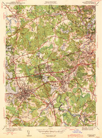
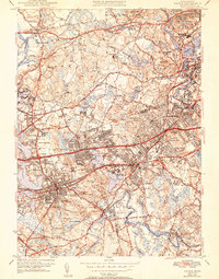
1943 Map of Natick
USGS Topo · Published 1943About this map
The Sudbury River and Charles River define the hydrography of this early 1940s landscape, bordering established educational anchors such as Wellesley College, Regis College, and the Babson Institute. The map captures the suburban transition of Middlesex and Norfolk counties during a period when the Boston and Albany RR and the Boston and Maine RR provided critical commuter links to the surrounding towns. Residential growth is evident in clusters around Wellesley Hills and Auburndale, while civic life is anchored by institutions like Morse Hospital and numerous neighborhood schools including Hardy Sch and Sprague Sch. A dense network of local cemeteries, such as Linwood Cem and St Patrick Cem, offers significant detail for genealogical research, while the presence of the Worcester Turnpike signals the evolving automotive infrastructure of the era.
Find a feature on this map
79 named features on this map. Tap any name to fly to it.
Don’t see what you’re looking for? This feature index may not catch every label — zoom into the map to look around manually.
Map Details
Editions of this 1943 Natick Map
5 editions found
Other maps of this area

1886 · Dedham
USGS Topo · 1:62,500

1886 · Framingham
USGS Topo · 1:62,500

1887 · Franklin
USGS Topo · 1:62,500

1889 · Franklin
USGS Topo · 1:62,500

1889 · Framingham
USGS Topo · 1:62,500

1893 · Franklin
USGS Topo · 1:62,500

1893 · Boston
USGS Topo · 1:62,500

1894 · Dedham
USGS Topo · 1:62,500

1894 · Framingham
USGS Topo · 1:62,500

1903 · Boston
USGS Topo · 1:62,500