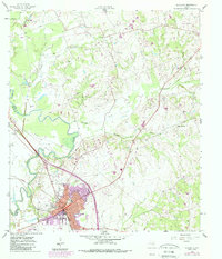
1958 Map of Navasota
USGS Topo · Published 1989About this map
The Navasota River serves as the dividing line between Grimes and Brazos counties, framing a landscape where agricultural traditions and early aviation intersect. The town of Navasota anchors the southern portion of the sheet, revealing a developed core with a Hospital, Rodeo Ground, and the nearby Navasota Municipal Airport. Local history is preserved in the numerous family and community burial sites scattered throughout the countryside, such as Steele Grove Cem, Erwin Cem, and Odd Fellows Cem.
Find a feature on this map
36 named features on this map. Tap any name to fly to it.
Don’t see what you’re looking for? This feature index may not catch every label — zoom into the map to look around manually.
Map Details
Editions of this 1958 Navasota Map
3 editions found
Other maps of this area

1913 · Millican
USGS Topo · 1:31,680

1914 · Navasota
USGS Topo · 1:62,500

1954 · Beaumont
USGS Topo · 1:250,000

1954 · Austin
USGS Topo · 1:250,000

1956 · Carlos
USGS Topo · 1:62,500

1957 · Beaumont
USGS Topo · 1:250,000

1958 · Washington
USGS Topo · 1:24,000

1958 · Navasota
USGS Topo · 1:24,000

1958 · Courtney
USGS Topo · 1:24,000

1959 · Millican
USGS Topo · 1:24,000