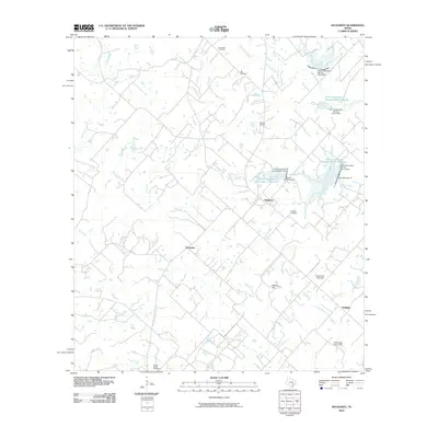
2010 Map of Nechanitz
USGS Topo · Published 2010About this map
Waldeck and the surrounding rural communities of Nechanitz and Walhalla define the landscape of this Fayette County region. The terrain is deeply carved by a dense network of waterways, including Pin Oak Creek, Cummins Creek, and Rocky Creek, which feed into numerous soil conservation reservoirs. These engineering features, such as the Soil Conservation Service Site 9 Reservoir and several associated dams, illustrate the mid-century transition toward controlled water management for agricultural stability in Central Texas. For genealogists, the map preserves the locations of significant family and community burial grounds, notably the Schumann Cemetery, Bell Cemetery, and Waldeck Cemetery. Small-scale aviation is represented by the Ullrich Airport, while named landmarks like Hellers Hill and the Anchorage Farm Field provide specific points of reference for local land history and heritage research.
Find a feature on this map
40 named features on this map. Tap any name to fly to it.
Don’t see what you’re looking for? This feature index may not catch every label — zoom into the map to look around manually.
Map Details
Editions of this 2010 Nechanitz Map
This is the sole edition of this map. No revisions or reprints were ever made.
Other maps of this area

1919 · Fayettsville
USGS Topo · 1:62,500

1919 · Giddings
USGS Topo · 1:62,500

1953 · Seguin
USGS Topo · 1:250,000

1954 · Austin
USGS Topo · 1:250,000

1956 · La Grange
USGS Topo · 1:62,500

1957 · La Grange East
USGS Topo · 1:24,000

1958 · La Grange West
USGS Topo · 1:24,000

1958 · Seguin
USGS Topo · 1:250,000

1958 · Ledbetter
USGS Topo · 1:24,000
1958 · Nechanitz
USGS Topo · 1:24,000