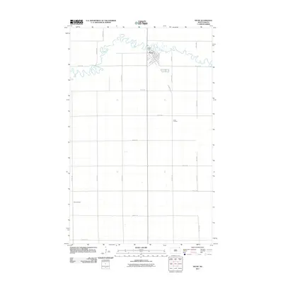
2011 Map of Neche
USGS Topo · Published 2011About this map
Neche sits at the northern edge of this Red River Valley landscape, its street grid defined by thoroughfares like Main Ave and Madison Ave. The highly sinuous Pembina River meanders across the northern portion of the map, held by the Neche Dam near the town center. The surrounding terrain is a strict agricultural grid, a pattern established by the Public Land Survey System and represented here by numerous section-line roads such as 146 Ave NE and 105th St NE. Local history is anchored by two distinct burial grounds: Union Cemetery to the east and Bruce Cemetery in the southwest quadrant, providing valuable reference points for genealogists researching families of Pembina County.
Find a feature on this map
26 named features on this map. Tap any name to fly to it.
Don’t see what you’re looking for? This feature index may not catch every label — zoom into the map to look around manually.
Map Details
Editions of this 2011 Neche Map
This is the sole edition of this map. No revisions or reprints were ever made.
Other maps of this area

1939 · Cavalier
USGS Topo · 1:62,500

1941 · Cavalier
USGS Topo · 1:62,500

1941 · Bathgate
USGS Topo · 1:62,500

1952 · Thief River Falls
USGS Topo · 1:250,000

1956 · Thief River Falls
USGS Topo · 1:250,000

1957 · Thief River Falls
USGS Topo · 1:250,000

1964 · Neche
USGS Topo · 1:24,000
1964 · Backoo
USGS Topo · 1:24,000
1964 · Cavalier
USGS Topo · 1:24,000
1964 · Cavalier NW
USGS Topo · 1:24,000