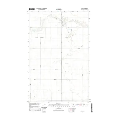
2014 Map of Neche
USGS Topo · Published 2014About this map
The Pembina River carves a winding path across the northern reaches of this borderland, where the Neche townsite sits just south of the Canadian boundary. The landscape here is defined by the subtle drainage of the Red River Valley, with the meandering river and its tributaries, Louden Coulee and Rosebud Coulee, cutting through a grid of section-line roads. For those researching local heritage, the map identifies the locations of Union Cem and Bruce Cem, situated amidst the agricultural tracts that characterize Pembina County. The street plan of Neche is clearly delineated, showing a mix of numerical streets like 7th St and named thoroughfares such as Madison Ave and Main Ave. This 2014 survey captures the enduring layout of this northern prairie community at a time when its proximity to the international border remains its most defining geographic feature.
Find a feature on this map
28 named features on this map. Tap any name to fly to it.
Don’t see what you’re looking for? This feature index may not catch every label — zoom into the map to look around manually.
Map Details
Editions of this 2014 Neche Map
This is the sole edition of this map. No revisions or reprints were ever made.
Other maps of this area

1939 · Cavalier
USGS Topo · 1:62,500

1941 · Cavalier
USGS Topo · 1:62,500

1941 · Bathgate
USGS Topo · 1:62,500

1952 · Thief River Falls
USGS Topo · 1:250,000

1956 · Thief River Falls
USGS Topo · 1:250,000

1957 · Thief River Falls
USGS Topo · 1:250,000

1964 · Neche
USGS Topo · 1:24,000
1964 · Backoo
USGS Topo · 1:24,000
1964 · Cavalier
USGS Topo · 1:24,000
1964 · Cavalier NW
USGS Topo · 1:24,000