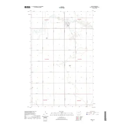
2017 Map of Neche
USGS Topo · Published 2017About this map
The Pembina River winds through the northern portion of this borderland landscape, defining the character of Neche, a town structured around a traditional grid of streets including Main Ave and Pennsylvania Ave. The surrounding terrain is primarily defined by its drainage patterns, with Louden Coulee and Rosebud Coulee carving subtle relief into the agricultural plains. For those researching local heritage, the map identifies significant land-use markers including Union Cem situated southeast of the town center and Bruce Cem located further south along the western edge. A robust network of section-line roads, such as Neche Rd and Felson Rd, organizes the rural space, illustrating the enduring influence of the Public Land Survey System on the modern North Dakota landscape.
Find a feature on this map
28 named features on this map. Tap any name to fly to it.
Don’t see what you’re looking for? This feature index may not catch every label — zoom into the map to look around manually.
Map Details
Editions of this 2017 Neche Map
This is the sole edition of this map. No revisions or reprints were ever made.
Other maps of this area

1939 · Cavalier
USGS Topo · 1:62,500

1941 · Cavalier
USGS Topo · 1:62,500

1941 · Bathgate
USGS Topo · 1:62,500

1952 · Thief River Falls
USGS Topo · 1:250,000

1956 · Thief River Falls
USGS Topo · 1:250,000

1957 · Thief River Falls
USGS Topo · 1:250,000

1964 · Neche
USGS Topo · 1:24,000
1964 · Backoo
USGS Topo · 1:24,000
1964 · Cavalier
USGS Topo · 1:24,000
1964 · Cavalier NW
USGS Topo · 1:24,000