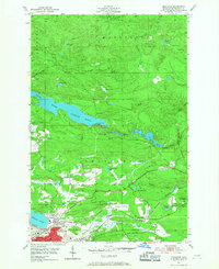
1953 Map of Negaunee
USGS Topo · Published 1968About this map
Negaunee serves as the industrial and civic anchor of this mid-century survey, situated in the heart of Michigan's iron range. The landscape is defined by its extraction history, prominently featuring the Maas Mine, Negaunee Mine, and Mather Mine B near the southern edge of the sheet. These operations are interconnected by a dense network of rail lines including the C & NW and the Duluth South Shore and Atlantic, illustrating the logistical complexity required to move ore from the Upper Peninsula mines to the Great Lakes ports.
Find a feature on this map
48 named features on this map. Tap any name to fly to it.
Don’t see what you’re looking for? This feature index may not catch every label — zoom into the map to look around manually.
Map Details
Editions of this 1953 Negaunee Map
4 editions found
Other maps of this area

1907 · Marquette
USGS Topo · 1:62,500

1932 · Harvey NW
USGS Topo · 1:31,680

1952 · Sands
USGS Topo · 1:24,000

1952 · Ishpeming
USGS Topo · 1:62,500

1952 · Ishpeming
USGS Topo · 1:24,000

1952 · Gwinn
USGS Topo · 1:62,500

1952 · Palmer
USGS Topo · 1:24,000

1953 · Marquette NW
USGS Topo · 1:24,000

1953 · Negaunee
USGS Topo · 1:24,000

1954 · Negaunee SW
USGS Topo · 1:24,000
Featured Places
- Negaunee, MI
- Negaunee Township, MI
- Marquette Township, MI
- Ishpeming Township, MI
- Beverly Hills, Negaunee