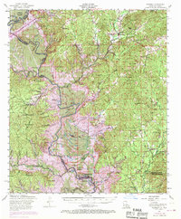
1954 Map of Negreet
USGS Topo · Published 1970About this map
The Sabine River carves a winding path through this 1954 landscape, defining the state boundary where Sabine National Forest meets the Louisiana backcountry. This survey, photorevised in 1969, documents the intricate drainage network of Negreet Bayou and Patroon Bayou just before the creation of the Toledo Bend Reservoir transformed the river valley. The map reveals a rural community anchored by small settlements like Sabinetown and Negreet, along with numerous country churches including Little Flock Church and Pleasant Hill Church.
Find a feature on this map
70 named features on this map. Tap any name to fly to it.
Don’t see what you’re looking for? This feature index may not catch every label — zoom into the map to look around manually.
Map Details
Editions of this 1954 Negreet Map
4 editions found

Other maps of this area

1941 · Leesville
USGS Topo · 1:62,500

1941 · Zwolle
USGS Topo · 1:62,500

1942 · Many
USGS Topo · 1:62,500

1942 · Florien
USGS Topo · 1:62,500

1943 · Leesville
USGS Topo · 1:62,500

1943 · Many
USGS Topo · 1:62,500

1944 · Negreet
USGS Topo · 1:62,500

1944 · Wiergate
USGS Topo · 1:62,500

1944 · Patroon
USGS Topo · 1:62,500

1944 · Florien
USGS Topo · 1:62,500