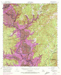
1954 Map of Negreet
USGS Topo · Published 1974About this map
The Sabine River defines the border between Louisiana and Texas in this mid-century survey, a region characterized by dense woodlands and a complex network of bayous and creeks. Within the Sabine National Forest, the landscape is dotted with small rural communities and spiritual centers such as Pendleton Church, Zion Hill Church, and Antioch Church. The topography is shaped by numerous water bodies including Cypress Pond and Cutoff Lake, alongside elevations like Rock Hill and Moss Hill. This edition includes purple photorevised overlays from 1969, which highlight significant changes in the drainage patterns and shorelines near Sabinetown and the Blackland Slough, likely reflecting the early impacts of regional reservoir planning. Local history is preserved through the mapping of remote family burial grounds like Roberts Cem and landmarks such as the Sabine Lookout Tower.
Find a feature on this map
74 named features on this map. Tap any name to fly to it.
Don’t see what you’re looking for? This feature index may not catch every label — zoom into the map to look around manually.
Map Details
Editions of this 1954 Negreet Map
4 editions found

Other maps of this area

1941 · Leesville
USGS Topo · 1:62,500

1941 · Zwolle
USGS Topo · 1:62,500

1942 · Many
USGS Topo · 1:62,500

1942 · Florien
USGS Topo · 1:62,500

1943 · Leesville
USGS Topo · 1:62,500

1943 · Many
USGS Topo · 1:62,500

1944 · Negreet
USGS Topo · 1:62,500

1944 · Wiergate
USGS Topo · 1:62,500

1944 · Patroon
USGS Topo · 1:62,500

1944 · Florien
USGS Topo · 1:62,500