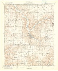
1916 Map of Neosho
USGS Topo · Published 1916About this map
Neosho serves as the focal point of this 1914 survey, situated at the confluence of several vital rail lines and local watercourses. The town's grid is surrounded by a dense network of early 20th-century rural infrastructure, including an unusually high concentration of named schools like Blackjack School, Jaybird School, and Five Points School. The presence of the St Louis and San Francisco RR and the Kansas City Southern underscores the region's importance as a transportation hub in Southwest Missouri, connecting agricultural lands like Diamond Grove Prairie to wider markets.
Find a feature on this map
58 named features on this map. Tap any name to fly to it.
Don’t see what you’re looking for? This feature index may not catch every label — zoom into the map to look around manually.
Map Details
Editions of this 1916 Neosho Map
5 editions found
Other maps of this area

1886 · Joplin
USGS Topo · 1:125,000

1886 · Carthage
USGS Topo · 1:125,000

1894 · Joplin
USGS Topo · 1:125,000

1894 · Carthage
USGS Topo · 1:125,000

1907 · Wyandotte
USGS Topo · 1:125,000

1909 · Wyandotte
USGS Topo · 1:125,000

1916 · Neosho
USGS Topo · 1:62,500

1921 · Sarcoxie
USGS Topo · 1:62,500

1940 · Noel
USGS Topo · 1:62,500

1941 · Rocky Comfort
USGS Topo · 1:62,500