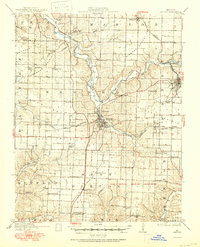
1916 Map of Neosho
USGS Topo · Published 1950About this map
Neosho serves as the focal point of this Newton County survey, situated at the confluence of Shoal Creek and Hickory Creek. The landscape transition is evident where the open terrain of Burkhart Prairie and Diamond Grove Prairie meets the more dissected hills to the south. This era shows a region shaped by extractive industry and military development, notably the expansive Camp Crowder Military Reservation and scattered lead and zinc operations like the Tiger Mine and Mascot Mine near Granby.
Find a feature on this map
63 named features on this map. Tap any name to fly to it.
Don’t see what you’re looking for? This feature index may not catch every label — zoom into the map to look around manually.
Map Details
Editions of this 1916 Neosho Map
5 editions found
Other maps of this area

1886 · Joplin
USGS Topo · 1:125,000

1886 · Carthage
USGS Topo · 1:125,000

1894 · Joplin
USGS Topo · 1:125,000

1894 · Carthage
USGS Topo · 1:125,000

1907 · Wyandotte
USGS Topo · 1:125,000

1909 · Wyandotte
USGS Topo · 1:125,000

1916 · Neosho
USGS Topo · 1:62,500

1921 · Sarcoxie
USGS Topo · 1:62,500

1940 · Noel
USGS Topo · 1:62,500

1941 · Rocky Comfort
USGS Topo · 1:62,500