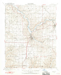
1916 Map of Neosho
USGS Topo · Published 1970About this map
Neosho serves as the central hub of this Missouri landscape, where the St. Louis and San Francisco and Kansas City Southern railroads converge amidst a series of distinct prairie uplands. The mapping captures a region defined by its diverse economic foundations, from the mining operations at Tiger Mine and Chase Mine near Granby to the expansive Camp Crowder Military Reservation in the southeast. Numerous rural institutions, such as Jaybird School, Possumtrot School, and Blackjack School, are scattered across the terrain, marking the social centers of early 20th-century farming communities. The waterways, including Shoal Creek and Buffalo Creek, dictate the movement of early transit routes like Seneca Road, while abandoned rail lines like the Missouri and North Arkansas hint at the shifting transportation priorities of the era.
Find a feature on this map
76 named features on this map. Tap any name to fly to it.
Don’t see what you’re looking for? This feature index may not catch every label — zoom into the map to look around manually.
Map Details
Editions of this 1916 Neosho Map
5 editions found
Other maps of this area

1886 · Joplin
USGS Topo · 1:125,000

1886 · Carthage
USGS Topo · 1:125,000

1894 · Joplin
USGS Topo · 1:125,000

1894 · Carthage
USGS Topo · 1:125,000

1907 · Wyandotte
USGS Topo · 1:125,000

1909 · Wyandotte
USGS Topo · 1:125,000

1916 · Neosho
USGS Topo · 1:62,500

1921 · Sarcoxie
USGS Topo · 1:62,500

1940 · Noel
USGS Topo · 1:62,500

1941 · Rocky Comfort
USGS Topo · 1:62,500