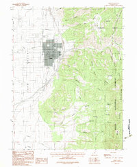
1983 Map of Nephi
USGS Topo · Published 1983About this map
The Juab Valley floor is anchored by the community of Nephi, where a systematic grid of streets transitions into the industrial and recreational outskirts of the town in the early 1980s. Evidence of local utility and transport infrastructure is visible in the Nephi Municipal Airport and nearby Sewage Disposal Ponds, while a Golf Course and a Parking Lot suggest the recreational footprint of the era. To the south, the settlement of Levan marks the valley's southern reach, nestled near Fourmile Creek.
Find a feature on this map
42 named features on this map. Tap any name to fly to it.
Don’t see what you’re looking for? This feature index may not catch every label — zoom into the map to look around manually.
Map Details
Editions of this 1983 Nephi Map
2 editions found
Other maps of this area

1885 · Manti
USGS Topo · 1:250,000

1895 · Manti
USGS Topo · 1:250,000

1951 · Moroni
USGS Topo · 1:62,500

1951 · Santaquin
USGS Topo · 1:62,500

1951 · Nephi
USGS Topo · 1:62,500

1952 · Santaquin Peak
USGS Topo · 1:62,500

1956 · Price
USGS Topo · 1:250,000

1960 · Price
USGS Topo · 1:250,000

1962 · Price
USGS Topo · 1:250,000
1979 · Slate Jack Canyon
USGS Topo · 1:24,000