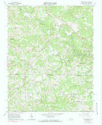
1967 Map of Nettleridge
USGS Topo · Published 1983About this map
The South Mayo River meanders across the hills of Patrick County, Virginia, and Stokes County, North Carolina, defining a landscape of small agricultural hubs and riverside mills during the mid-1960s. The presence of Gilbert Mill on Russell Creek and an Old Railroad Grade near Spoon Creek points to an era of localized industry and rural transport. This survey captures a specific moment in the borderlands, where small post-war settlements like Coleville and Palmetto were anchored by neighborhood landmarks such as Tatum Macedonia Ch and New Hope Sch. Community life is further evidenced by family-run commercial points like Moorefield Store, Lackey Store, and Shelton Store, providing a detailed look at the distribution of local commerce before modern consolidation shifted the region's character. Topographic details like High Point Ch and Peters Creek illustrate the rolling transition from the Piedmont into the Blue Ridge foothills.
Find a feature on this map
38 named features on this map. Tap any name to fly to it.
Don’t see what you’re looking for? This feature index may not catch every label — zoom into the map to look around manually.
Map Details
Editions of this 1967 Nettleridge Map
3 editions found
Other maps of this area

1926 · Critz
USGS Topo · 1:48,000

1928 · Stuart
USGS Topo · 1:48,000

1928 · Critz
USGS Topo · 1:62,500

1931 · Stuart
USGS Topo · 1:62,500

1953 · Winston-Salem
USGS Topo · 1:250,000

1955 · Winston-Salem
USGS Topo · 1:250,000

1962 · Winston-Salem
USGS Topo · 1:250,000

1964 · Hanging Rock
USGS Topo · 1:24,000

1967 · Patrick Springs
USGS Topo · 1:24,000
1967 · Spencer
USGS Topo · 1:24,000