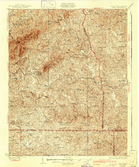
1928 Map of Critz
USGS Topo · Published 1943About this map
The Danville and Western RR winds through the hills of Patrick County, anchoring a landscape of small settlements and agrarian industry between the Blue Ridge and the Virginia-North Carolina border. This survey from the 1920s reveals an intricate network of rural infrastructure, where local life centered on family-named landmarks such as Rogers Mill and Reynolds Mill. The settlement of Critz sits as a central point, while higher elevations like No Business Mountain and Gabes Knob overlook a valley filled with dozens of community anchors, including the Blue Ridge Mission Sch and Mountain View Ch. The distribution of scattered schools like Race Track Sch and Anthony Sch alongside general stores like Kogers Store suggests a period when these small hubs were the primary social and economic intersections for tobacco farmers and mountain residents before modern highway consolidation.
Find a feature on this map
85 named features on this map. Tap any name to fly to it.
Don’t see what you’re looking for? This feature index may not catch every label — zoom into the map to look around manually.
Map Details
Editions of this 1928 Critz Map
3 editions found
Other maps of this area

1924 · Martinsville
USGS Topo · 1:48,000

1925 · Rocky Mount
USGS Topo · 1:48,000

1926 · Martinsville
USGS Topo · 1:62,500

1926 · Critz
USGS Topo · 1:48,000

1927 · Rocky Mount
USGS Topo · 1:62,500

1927 · Martinsville
USGS Topo · 1:62,500

1928 · Stuart
USGS Topo · 1:48,000

1928 · Critz
USGS Topo · 1:62,500

1931 · Stuart
USGS Topo · 1:62,500

1944 · Martinsville
USGS Topo · 1:62,500