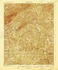
1928 Map of Critz
USGS Topo · Published 1928About this map
The Danville and Western Railway winds through the southern foothills of the Blue Ridge in the late 1920s, serving a landscape defined by small-scale milling and rural commerce. This survey captures a dense network of mountain communities centered around family-run landmarks like Stones Store and Rogers Mill. The topography is marked by significant heights such as Bull Mountain and No Business Mountain, while the valleys are populated by numerous small institutions, including the Blue Ridge Mission Sch and Minnie Chapel.
Find a feature on this map
108 named features on this map. Tap any name to fly to it.
Don’t see what you’re looking for? This feature index may not catch every label — zoom into the map to look around manually.
Map Details
Editions of this 1928 Critz Map
3 editions found
Other maps of this area

1924 · Martinsville
USGS Topo · 1:48,000

1925 · Rocky Mount
USGS Topo · 1:48,000

1926 · Martinsville
USGS Topo · 1:62,500

1926 · Critz
USGS Topo · 1:48,000

1927 · Rocky Mount
USGS Topo · 1:62,500

1927 · Martinsville
USGS Topo · 1:62,500

1928 · Stuart
USGS Topo · 1:48,000

1928 · Critz
USGS Topo · 1:62,500

1931 · Stuart
USGS Topo · 1:62,500

1944 · Martinsville
USGS Topo · 1:62,500