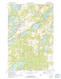
1970 Map of Nevis
USGS Topo · Published 1991About this map
The settlement of Nevis serves as the focal point for this 1970s landscape, situated along the Burlington Northern railroad corridor. The area is defined by an intricate chain of glacial lakes, including the distinctive sequence from Fourth Crow Wing Lake through Tenth Crow Wing Lake, which eventually feed the Crow Wing River. This water-rich environment is a study in early northern Minnesota recreation and rural infrastructure, featuring a Landing Field near the town center and numerous lakefront camps.
Find a feature on this map
35 named features on this map. Tap any name to fly to it.
Don’t see what you’re looking for? This feature index may not catch every label — zoom into the map to look around manually.
Map Details
Editions of this 1970 Nevis Map
2 editions found
Other maps of this area

1953 · Brainerd
USGS Topo · 1:250,000

1954 · Bemidji
USGS Topo · 1:250,000

1957 · Brainerd
USGS Topo · 1:250,000

1957 · Bemidji
USGS Topo · 1:250,000

1958 · Bemidji
USGS Topo · 1:250,000

1958 · Brainerd
USGS Topo · 1:250,000

1965 · Brainerd
USGS Topo · 1:250,000

1970 · Nevis
USGS Topo · 1:24,000

1970 · Dorset
USGS Topo · 1:24,000
1970 · Huntersville
USGS Topo · 1:24,000