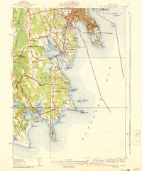
1941 Map of New Bedford South
USGS Topo · Published 1941About this map
Butler Flats Lighthouse stands at the entrance to the outer harbor, marking a coastline defined by the maritime and institutional development of South Dartmouth and New Bedford just before the United States entered World War II. The landscape is characterized by a mix of coastal estates and critical infrastructure, including the Solemar Hospital on Clark Cove and the defensive installations at Fort Rodman. Residential clusters such as Nonquitt and Bliss Corner reflect the region's suburban growth during the mid-century, while the interior remains dotted with small community centers like Bakersville. This survey preserves the exact locations of numerous educational and religious sites, such as the Smiths Neck Ch and Crapo Sch, providing a detailed look at the social fabric of Dartmouth before modern expansion altered these rural road networks.
Find a feature on this map
78 named features on this map. Tap any name to fly to it.
Don’t see what you’re looking for? This feature index may not catch every label — zoom into the map to look around manually.
Map Details
Editions of this 1941 New Bedford South Map
3 editions found
Other maps of this area

1885 · New Bedford
USGS Topo · 1:62,500

1885 · Sakonnet
USGS Topo · 1:62,500

1887 · Gay Head
USGS Topo · 1:62,500

1888 · New Bedford
USGS Topo · 1:62,500

1888 · Fall River
USGS Topo · 1:62,500

1888 · Sakonnet
USGS Topo · 1:62,500

1889 · Gay Head
USGS Topo · 1:62,500

1893 · Gay Head
USGS Topo · 1:62,500

1893 · Sakonnet
USGS Topo · 1:62,500

1893 · Fall River
USGS Topo · 1:62,500