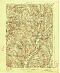
1912 Map of New Berlin
USGS Topo · Published 1923About this map
The Unadilla River and its meandering valley dictate the settlement patterns of this early twentieth-century landscape, serving as the border between several rural townships. The New York Ontario & Western RR snakes through the river valley, connecting dairy-focused hamlets such as South New Berlin and South Edmeston to wider markets. Uplands are dotted with family-named landmarks and essential community institutions like the Columbus Hill Church and various district schools including the East Hill School and Dimock Hollow School.
Find a feature on this map
68 named features on this map. Tap any name to fly to it.
Don’t see what you’re looking for? This feature index may not catch every label — zoom into the map to look around manually.
Map Details
Editions of this 1912 New Berlin Map
4 editions found
Other maps of this area

1902 · Coventry
USGS Topo · 1:62,500

1902 · Morrisville
USGS Topo · 1:62,500

1903 · Norwich
USGS Topo · 1:62,500

1904 · Oxford
USGS Topo · 1:62,500

1907 · Winfield
USGS Topo · 1:62,500

1907 · Sangerfield
USGS Topo · 1:62,500

1910 · Hartwick
USGS Topo · 1:62,500

1910 · New Berlin
USGS Topo · 1:62,500

1912 · New Berlin
USGS Topo · 1:62,500

1912 · Hartwick
USGS Topo · 1:62,500