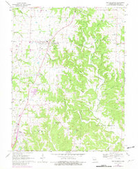
1969 Map of New Bloomfield
USGS Topo · Published 1982About this map
New Bloomfield serves as the central hub for this rural Callaway County landscape during the late 1960s, a period marked by established agricultural patterns and emerging communications infrastructure. The map reveals a dense network of family-named cemeteries such as Caldwell Cem, King Cem, and James Cem, which speak to the long-standing genealogical roots of the local townships like Cedar and Caldwell. The prominence of the KRCG-TV Radio Tower near the town center highlights the area's role in regional broadcasting.
Find a feature on this map
52 named features on this map. Tap any name to fly to it.
Don’t see what you’re looking for? This feature index may not catch every label — zoom into the map to look around manually.
Map Details
Editions of this 1969 New Bloomfield Map
2 editions found
Other maps of this area

1886 · Jefferson City
USGS Topo · 1:125,000

1890 · Fulton
USGS Topo · 1:125,000

1894 · Jefferson City
USGS Topo · 1:125,000

1928 · Fulton
USGS Topo · 1:62,500

1931 · Fulton
USGS Topo · 1:62,500

1939 · Jefferson City
USGS Topo · 1:24,000

1939 · Jefferson City
USGS Topo · 1:62,500

1942 · Jefferson City
USGS Topo · 1:62,500

1944 · Millersburg
USGS Topo · 1:62,500

1945 · Mokane
USGS Topo · 1:62,500