
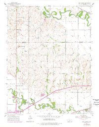
1955 Map of New Cambria
USGS Topo · Published 1956About this map
Meandering river valleys define the agricultural landscape of central Kansas in the mid-1950s, where the Solomon River and Saline River converge toward the east. The township of Cambria is anchored by the community of New Cambria along the Union Pacific railroad, while the settlement of Verdi occupies the northeastern corner. This period shows a high density of rural schoolhouses, including the Saline Valley Gem Humbargar Sch, Pleasant Hill Sch, and Schipple Sch, reflecting the local-district educational system before widespread consolidation.
Find a feature on this map
20 named features on this map. Tap any name to fly to it.
Don’t see what you’re looking for? This feature index may not catch every label — zoom into the map to look around manually.
Map Details
Editions of this 1955 New Cambria Map
2 editions found
Other maps of this area

1889 · Abilene
USGS Topo · 1:125,000

1891 · Clay Center
USGS Topo · 1:125,000

1892 · Salina
USGS Topo · 1:125,000

1892 · Minneapolis
USGS Topo · 1:125,000

1894 · Abilene
USGS Topo · 1:125,000

1942 · Salina
USGS Topo · 1:125,000

1955 · Salina
USGS Topo · 1:24,000

1955 · Salina SW
USGS Topo · 1:24,000

1955 · Trenton
USGS Topo · 1:24,000

1955 · Niles
USGS Topo · 1:24,000