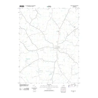
2010 Map of New Castle
USGS Topo · Published 2010About this map
New Castle serves as the central hub of this Henry County landscape, where the street grid transitions into a dense network of named rural roads and watercourses. The hydrology of the region is particularly detailed, defined by the winding paths of the Little Kentucky River and numerous tributaries such as White Sulphur Fork, Fallen Timber Creek, and Town Creek. To the south, Eminence Lake and the Henry County Rod and Gun Club Lake provide significant local landmarks alongside private aviation sites like the John M Foree Airport and Deer Run Farm Airport. The map documents a contemporary rural Kentucky layout, where family-named lanes like Scobie Ln and Dixon Ln branch off from established routes such as Mount Gilead Rd, illustrating the intersection of modern property divisions with traditional creek-bottom topography.
Find a feature on this map
34 named features on this map. Tap any name to fly to it.
Don’t see what you’re looking for? This feature index may not catch every label — zoom into the map to look around manually.
Map Details
Editions of this 2010 New Castle Map
This is the sole edition of this map. No revisions or reprints were ever made.
Other maps of this area

1928 · New Castle
USGS Topo · 1:48,000

1932 · New Castle
USGS Topo · 1:62,500

1932 · La Grange
USGS Topo · 1:62,500

1952 · Worthville
USGS Topo · 1:24,000

1952 · Campbellsburg
USGS Topo · 1:24,000

1953 · Bedford
USGS Topo · 1:24,000

1954 · Ballardsville
USGS Topo · 1:24,000
1954 · New Castle
USGS Topo · 1:24,000
1954 · Eminence
USGS Topo · 1:24,000
1954 · Smithfield
USGS Topo · 1:24,000