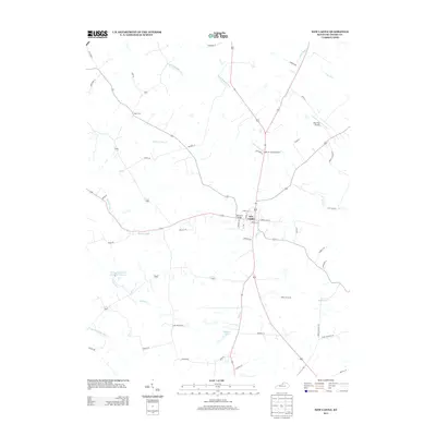
2013 Map of New Castle
USGS Topo · Published 2013About this map
New Castle serves as the focal point of this Henry County survey, situated at the intersection of several regional routes including Eminence Rd and Cedar St. The surrounding landscape is defined by a dense network of watercourses, with the Little Kentucky River and White Sulphur Fork carving through the terrain. Notable local infrastructure includes the John M. Foree Airport and Deer Run Airpark, reflecting the importance of light aviation in this rural corridor. Genealogists and local historians can locate several family-named landmarks and historical sites, such as the Logan Cem and the crossing at Simmons Bridge. The map also captures significant recreational and agricultural features like the Henry County Rod and Gun Club Lake and Eminence Lake, which anchor the southern portion of the quadrangle.
Find a feature on this map
50 named features on this map. Tap any name to fly to it.
Don’t see what you’re looking for? This feature index may not catch every label — zoom into the map to look around manually.
Map Details
Editions of this 2013 New Castle Map
This is the sole edition of this map. No revisions or reprints were ever made.
Other maps of this area

1928 · New Castle
USGS Topo · 1:48,000

1932 · New Castle
USGS Topo · 1:62,500

1932 · La Grange
USGS Topo · 1:62,500

1952 · Worthville
USGS Topo · 1:24,000

1952 · Campbellsburg
USGS Topo · 1:24,000

1953 · Bedford
USGS Topo · 1:24,000

1954 · Ballardsville
USGS Topo · 1:24,000
1954 · New Castle
USGS Topo · 1:24,000
1954 · Eminence
USGS Topo · 1:24,000
1954 · Smithfield
USGS Topo · 1:24,000