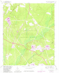
1965 Map of New Ellenton SW
USGS Topo · Published 1981About this map
The U S Reservation Savannah River Plant Department of Energy dominates this landscape, showing the complex industrial and security infrastructure of the Cold War era. Established on the border of Aiken and Barnwell counties, the site is defined by a strictly managed Government Boundary and its own internal transportation network, including the U S Govt RR. The terrain is characterized by the hydrological system of Upper Three Runs, which is fed by tributaries like Tinker Cr and Fourmile Branch. Amidst the modern industrial facilities and substations, the presence of Green Pond Ch serves as a lone reminder of the local communities that existed before the federal government acquired the land for atomic energy production. The map's specialized details, such as the Indefinite Boundary and various government installations, reflect the unique status of this restricted area during the early 1960s.
Find a feature on this map
12 named features on this map. Tap any name to fly to it.
Don’t see what you’re looking for? This feature index may not catch every label — zoom into the map to look around manually.
Map Details
Editions of this 1965 New Ellenton SW Map
3 editions found
Other maps of this area

1920 · Ellenton
USGS Topo · 1:48,000

1920 · Greens Cut
USGS Topo · 1:62,500

1920 · Talatha
USGS Topo · 1:48,000

1921 · Augusta
USGS Topo · 1:62,500

1921 · Talatha
USGS Topo · 1:62,500

1921 · Ellenton
USGS Topo · 1:62,500

1943 · Greens Cut
USGS Topo · 1:62,500

1943 · Augusta East
USGS Topo · 1:125,000

1943 · Talatha
USGS Topo · 1:62,500

1943 · Augusta
USGS Topo · 1:62,500