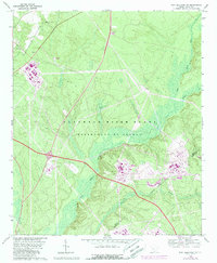
1965 Map of New Ellenton SW
USGS Topo · Published 1989About this map
The Savannah River Plant (Department of Energy) occupies the majority of this landscape, reflecting its mid-century role as a massive nuclear production site. The map shows the sprawling industrial footprint required for Cold War energy production, with numerous substations and tank structures connected by a rigid network of specialized roads. Despite the heavy industrial overlay, remnants of the area's rural past persist in small pockets, including Green Pond Ch and Ford Cem near the northern boundary. The terrain is defined by the natural drainage of Upper Three Runs and Fourmile Branch, which wind through the heavy woodland that surrounds the facility. An Aiken Co Barnwell Co line cuts through the southern portion of the quadrangle, illustrating how the federal reservation straddles local political boundaries.
Find a feature on this map
11 named features on this map. Tap any name to fly to it.
Don’t see what you’re looking for? This feature index may not catch every label — zoom into the map to look around manually.
Map Details
Editions of this 1965 New Ellenton SW Map
3 editions found
Other maps of this area

1920 · Ellenton
USGS Topo · 1:48,000

1920 · Greens Cut
USGS Topo · 1:62,500

1920 · Talatha
USGS Topo · 1:48,000

1921 · Augusta
USGS Topo · 1:62,500

1921 · Talatha
USGS Topo · 1:62,500

1921 · Ellenton
USGS Topo · 1:62,500

1943 · Greens Cut
USGS Topo · 1:62,500

1943 · Augusta East
USGS Topo · 1:125,000

1943 · Talatha
USGS Topo · 1:62,500

1943 · Augusta
USGS Topo · 1:62,500