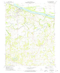
1973 Map of New Haven
USGS Topo · Published 1975About this map
The Missouri River corridor defines the northern landscape of this region, where the town of New Haven serves as a primary hub. The Pacific railroad line tracks the riverbank, supporting the local economy alongside numerous quarries and a claypit scattered throughout the hills. Moving south from the river valley, the terrain transitions into a more rural settlement pattern characterized by small community centers and family-named landmarks.
Find a feature on this map
41 named features on this map. Tap any name to fly to it.
Don’t see what you’re looking for? This feature index may not catch every label — zoom into the map to look around manually.
Map Details
Editions of this 1973 New Haven Map
This is the sole edition of this map. No revisions or reprints were ever made.
Other maps of this area

1890 · Hermann
USGS Topo · 1:125,000

1903 · Sullivan
USGS Topo · 1:125,000

1935 · Gerald
USGS Topo · 1:48,000

1936 · Hermann
USGS Topo · 1:48,000

1941 · Gerald
USGS Topo · 1:62,500

1942 · Hermann
USGS Topo · 1:62,500

1944 · Gerald
USGS Topo · 1:62,500

1945 · Hermann
USGS Topo · 1:62,500

1946 · Union
USGS Topo · 1:62,500

1948 · Union
USGS Topo · 1:62,500