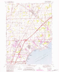
1968 Map of New Haven
USGS Topo · Published 1984About this map
Anchor Bay shoreline development and the inland agricultural grids of Macomb County define this landscape during a period of significant suburban expansion. The northern reaches are characterized by established farming settlements like New Haven and Meade, where the Grand Trunk Western railroad and the Ray-Lenox Drain intersect a landscape of country schools and churches such as St Francis Ch. Further south, the map reveals the rapid transition from rural acreage to residential subdivisions, visible in the growth of Chesterfield and the meticulously planned streets of Sebille Manor.
Find a feature on this map
79 named features on this map. Tap any name to fly to it.
Don’t see what you’re looking for? This feature index may not catch every label — zoom into the map to look around manually.
Map Details
Editions of this 1968 New Haven Map
3 editions found
Other maps of this area

1912 · Mt Clemens
USGS Topo · 1:62,500

1914 · Armada
USGS Topo · 1:62,500

1914 · Algonac
USGS Topo · 1:62,500

1928 · Armada
USGS Topo · 1:62,500

1928 · Hicky
USGS Topo · 1:62,500

1929 · Mt Clemens
USGS Topo · 1:62,500

1936 · New Haven
USGS Topo · 1:31,680

1936 · Waldenburg
USGS Topo · 1:31,680

1936 · Selfridge Field
USGS Topo · 1:31,680

1936 · New Baltimore
USGS Topo · 1:31,680
Featured Places
- Clinton Township, MI
- Macomb Township, MI
- Chesterfield Township, MI
- Harrison Township, MI
- New Baltimore, MI