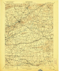
1908 Map of New Holland
USGS Topo · Published 1921About this map
Ephrata and New Holland anchor this detailed study of the Pennsylvania Dutch Country during a time of significant transition. The landscape is defined by a dense network of early thoroughfares like the New Holland Turnpike and Philadelphia and Lancaster Turnpike, which supported a flourishing agricultural economy long before modern highways. The presence of the Conestoga Electric Railway running through Leola and Bareville illustrates the early 20th-century push for regional connectivity, linking smaller settlements such as Blue Ball and Goodville to the larger rail hubs of the Pennsylvania Railroad.
Find a feature on this map
140 named features on this map. Tap any name to fly to it.
Don’t see what you’re looking for? This feature index may not catch every label — zoom into the map to look around manually.
Map Details
Editions of this 1908 New Holland Map
6 editions found


Other maps of this area

1891 · Lebanon
USGS Topo · 1:62,500

1893 · Lebanon
USGS Topo · 1:62,500

1894 · Reading
USGS Topo · 1:62,500

1899 · Lebanon
USGS Topo · 1:62,500

1902 · Wernersville
USGS Topo · 1:62,500

1902 · Lancaster
USGS Topo · 1:62,500

1904 · Lancaster
USGS Topo · 1:62,500

1904 · Coatesville
USGS Topo · 1:62,500

1905 · Honey Brook
USGS Topo · 1:62,500

1906 · Coatesville
USGS Topo · 1:62,500