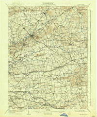
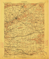
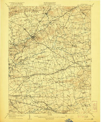
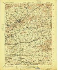
1908 Map of New Holland
USGS Topo · Published 1938About this map
The agrarian landscape of Lancaster County is meticulously detailed here, showing a dense network of turnpikes and electric railways serving established Pennsylvania Dutch communities. Significant transportation corridors like the Philadelphia and Lancaster Turnpike and the Reading RR connect the manufacturing hub of Ephrata and the borough of New Holland to the broader region. The map captures a transition in local commerce, where traditional post offices like Monterey Groffs Store PO and Greenville Mill PO anchor small crossroads. One distinctive feature is the sheer density of rural education and worship, with dozens of family-named landmarks such as the Metzler School and Middle Creek Church dotting the terrain. The presence of the Conestoga Electric RR alongside older coach roads illustrates the early 20th-century modernization of rural travel before the full dominance of the automobile.
Find a feature on this map
201 named features on this map. Tap any name to fly to it.
Don’t see what you’re looking for? This feature index may not catch every label — zoom into the map to look around manually.
Map Details
Editions of this 1908 New Holland Map
6 editions found


Other maps of this area

1891 · Lebanon
USGS Topo · 1:62,500

1893 · Lebanon
USGS Topo · 1:62,500

1894 · Reading
USGS Topo · 1:62,500

1899 · Lebanon
USGS Topo · 1:62,500

1902 · Wernersville
USGS Topo · 1:62,500

1902 · Lancaster
USGS Topo · 1:62,500

1904 · Lancaster
USGS Topo · 1:62,500

1904 · Coatesville
USGS Topo · 1:62,500

1905 · Honey Brook
USGS Topo · 1:62,500

1906 · Coatesville
USGS Topo · 1:62,500