
1969 Map of New Hope Dam
USGS Topo · Published 1973About this map
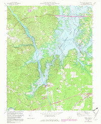
The New Hope Dam, noted as under construction during this 1969 field check, stands as the central feature of a landscape in transition. Blue hatching across the terrain indicates the extensive areas destined for submergence by the reservoir, illustrating a moment before the valley's topography was permanently altered. The confluence of the Haw River and the New Hope River defines the southern portion of the quadrangle, where Gunter-Harris Island sits at the fork.
Find a feature on this map
30 named features on this map. Tap any name to fly to it.
Don’t see what you’re looking for? This feature index may not catch every label — zoom into the map to look around manually.
Map Details
Editions of this 1969 New Hope Dam Map
2 editions found
Other maps of this area

1943 · Durham South
USGS Topo · 1:62,500

1951 · Farrington
USGS Topo · 1:24,000

1951 · Durham South
USGS Topo · 1:62,500

1953 · Raleigh
USGS Topo · 1:250,000

1954 · Raleigh
USGS Topo · 1:250,000

1968 · Bynum
USGS Topo · 1:24,000

1970 · Pittsboro
USGS Topo · 1:24,000

1970 · Colon
USGS Topo · 1:24,000

1970 · Moncure
USGS Topo · 1:24,000
1973 · Green Level
USGS Topo · 1:24,000