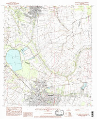
1983 Map of New Iberia North
USGS Topo · Published 1983About this map
St Martinville and the northern reaches of New Iberia anchor this early 1980s survey, illustrating the deep connection between Cajun culture and the winding course of Bayou Teche. The landscape is defined by the sharp transition from the dense urban grids of the parish seats to the sprawling agricultural tracts and drainage coulees that feed the basin. Local educational institutions like the Voc-Tech Sch and Carlson High Sch appear alongside residential developments and industrial centers, reflecting the region's mid-century growth. To the west, the massive expanse of Spanish Lake and the Acadiana Regional Airport represent significant modern alterations to the terrain. The infrastructure of the Southern Pacific railroad remains a primary transit corridor, cutting through smaller rural communities such as Segura, Independent, and Daspit, providing a clear look at the historic transport patterns of the Teche country.
Find a feature on this map
28 named features on this map. Tap any name to fly to it.
Don’t see what you’re looking for? This feature index may not catch every label — zoom into the map to look around manually.
Map Details
Editions of this 1983 New Iberia North Map
This is the sole edition of this map. No revisions or reprints were ever made.
Other maps of this area

1937 · Jeanerette
USGS Topo · 1:62,500

1937 · Derouen
USGS Topo · 1:62,500

1939 · St. Martinsville
USGS Topo · 1:62,500

1941 · Loreauville
USGS Topo · 1:62,500

1945 · New Orleans
USGS Topo · 1:250,000

1954 · Loreauville
USGS Topo · 1:62,500

1954 · Jeanerette
USGS Topo · 1:62,500

1954 · Baton Rouge
USGS Topo · 1:250,000

1956 · Baton Rouge
USGS Topo · 1:250,000

1957 · St. Martinville
USGS Topo · 1:62,500