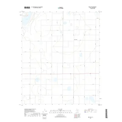
2019 Map of New Lynn
USGS Topo · Published 2019About this map
New Lynn sits at the center of this agricultural landscape in Lynn County, characterized by a vast network of section roads and scattered ephemeral basins. The terrain is defined by its regularity, with a grid of local routes including Co Rd 20 and Co Rd AA carving the plains into precise blocks. In the northwest corner, the distinct depression of Tahoka Lake provides a natural contrast to the surrounding fields, marking a significant hydrological feature in this semi-arid region. State and ranch roads such as Fm 1054 and Ranch Rd 2956 provide the primary transit corridors through the territory. This 2019 survey illustrates the enduring rural structure of the South Plains, where the settlement pattern remains tied to the intersection of numbered county roads and the management of local water resources.
Find a feature on this map
18 named features on this map. Tap any name to fly to it.
Don’t see what you’re looking for? This feature index may not catch every label — zoom into the map to look around manually.
Map Details
Editions of this 2019 New Lynn Map
This is the sole edition of this map. No revisions or reprints were ever made.
Other maps of this area

1954 · Lubbock
USGS Topo · 1:250,000

1957 · New Home
USGS Topo · 1:62,500

1965 · Southland
USGS Topo · 1:24,000

1965 · Wilson
USGS Topo · 1:24,000

1969 · Skeen Lake
USGS Topo · 1:24,000

1969 · Tahoka
USGS Topo · 1:24,000

1969 · Grassland SE
USGS Topo · 1:24,000

1970 · New Lynn
USGS Topo · 1:24,000
1970 · Draw
USGS Topo · 1:24,000

1970 · Grassland
USGS Topo · 1:24,000