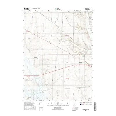
2016 Map of New Pittsburg
USGS Topo · Published 2016About this map
Funk Bottoms and the marshy expanses of the Muddy Fork dominate the southern landscape of this Wayne County region, where agricultural patterns are shaped by the winding courses of Fox Run and Killbuck Creek. The area is characterized by a dense network of early transportation routes, including Old Lincoln Way and Ashland Rd, which connect a series of established settlements and rural crossroads. Genealogists and local historians will find significant value in the distribution of community landmarks, from the Plain Lutheran Cem in the southeast to the Yankeetown Cem and Reedsburg Cem further west. Smaller hamlets like New Pittsburg, Blachleyville, and Jefferson serve as focal points for the surrounding township sections. The presence of Gorman-Green Airport and various religious sites, such as the Overton Church of God Cem, highlights the long-standing social and infrastructure developments within this traditional Ohio farming territory.
Find a feature on this map
118 named features on this map. Tap any name to fly to it.
Don’t see what you’re looking for? This feature index may not catch every label — zoom into the map to look around manually.
Map Details
Editions of this 2016 New Pittsburg Map
This is the sole edition of this map. No revisions or reprints were ever made.
Other maps of this area

1901 · Wooster
USGS Topo · 1:62,500

1903 · Wooster
USGS Topo · 1:62,500

1906 · West Salem
USGS Topo · 1:62,500

1908 · West Salem
USGS Topo · 1:62,500

1912 · Loudonville
USGS Topo · 1:62,500

1914 · Loudonville
USGS Topo · 1:62,500

1915 · Millersburg
USGS Topo · 1:62,500

1943 · Millersburg
USGS Topo · 1:62,500

1943 · Loudonville
USGS Topo · 1:62,500

1950 · Marion
USGS Topo · 1:250,000