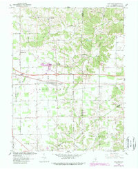
1961 Map of New Point
USGS Topo · Published 1988About this map
New Point serves as the central hub of this Indiana landscape, situated at the intersection of a developing interstate and local rural routes. In this era, the town’s character is defined by its proximity to several distinct crossroads settlements like Rossburg and New Pennington, while the outskirts are marked by active Quarries and industrial elements such as a Landing Strip and Gas Well. The natural geography is defined by the branching waters of Salt Creek and Laughery Creek, which wind through the township boundaries of Salt Creek, Ray, and Fugit.
Find a feature on this map
50 named features on this map. Tap any name to fly to it.
Don’t see what you’re looking for? This feature index may not catch every label — zoom into the map to look around manually.
Map Details
Editions of this 1961 New Point Map
4 editions found
Other maps of this area

1946 · Pierceville
USGS Topo · 1:24,000

1946 · Batesville
USGS Topo · 1:24,000

1946 · Osgood
USGS Topo · 1:24,000

1946 · New Point
USGS Topo · 1:24,000

1953 · Cincinnati
USGS Topo · 1:250,000

1956 · Metamora
USGS Topo · 1:24,000

1957 · Cincinnati
USGS Topo · 1:250,000

1958 · Greensburg
USGS Topo · 1:24,000

1958 · Millhousen
USGS Topo · 1:24,000

1958 · Clarksburg
USGS Topo · 1:24,000