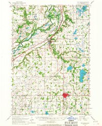
1957 Map of New Prague
USGS Topo · Published 1967About this map
The Minnesota River valley and its surrounding floodplains dominate this mid-century landscape, where the Chicago and North Western railroad tracks run parallel to the winding riverbanks. The survey captures a high concentration of rural education and religious centers, including East Union Ch and St Josephs Sch, alongside several schoolhouses already marked as abandoned, such as School No 25 (Abandoned) and School No 62 (Abandoned). These labels indicate the shifting demographics of the Minnesota countryside as small district schools began to consolidate.
Find a feature on this map
84 named features on this map. Tap any name to fly to it.
Don’t see what you’re looking for? This feature index may not catch every label — zoom into the map to look around manually.
Map Details
Editions of this 1957 New Prague Map
2 editions found

Other maps of this area

1896 · Minneapolis
USGS Topo · 1:62,500

1901 · Minneapolis
USGS Topo · 1:62,500

1905 · Minnetonka
USGS Topo · 1:62,500

1907 · Minnetonka
USGS Topo · 1:62,500

1953 · Saint Paul
USGS Topo · 1:250,000

1954 · Eden Prairie
USGS Topo · 1:24,000

1954 · Minneapolis
USGS Topo · 1:62,500

1957 · Belle Plaine
USGS Topo · 1:62,500

1957 · Prior Lake
USGS Topo · 1:62,500

1957 · Waconia
USGS Topo · 1:62,500