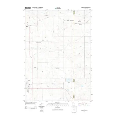
2013 Map of New Richland
USGS Topo · Published 2013About this map
The Le Sueur River and its tributary, the Little Le Sueur River, carve a winding path through this agricultural landscape in southern Minnesota. The town of New Richland stands as the primary hub, where the local Post Office and Calvary Cem are located. This area is characterized by its deep Lutheran heritage, evidenced by a high density of rural religious sites such as the Vista Swedish Lutheran Church Cem, Pontoppidan Lutheran Cem, and the Le Sueur River American Lutheran Church Cem. The small settlements of Otisco, Vista, and Lemond are connected by a grid of section roads like 295th Ave and MN-13, which navigate the terrain between glacial features like Saint Olaf Lake and Reese Lake. This survey provides a clear view of the longstanding land divisions and family-associated landmarks, including the Johnson Oakside Orchard, which reflect the region's enduring farming tradition.
Find a feature on this map
54 named features on this map. Tap any name to fly to it.
Don’t see what you’re looking for? This feature index may not catch every label — zoom into the map to look around manually.
Map Details
Editions of this 2013 New Richland Map
This is the sole edition of this map. No revisions or reprints were ever made.
Other maps of this area

1953 · Saint Paul
USGS Topo · 1:250,000

1954 · Mason City
USGS Topo · 1:250,000

1957 · Mason City
USGS Topo · 1:250,000

1958 · Mason City
USGS Topo · 1:250,000

1959 · Saint Paul
USGS Topo · 1:250,000

1962 · Saco
USGS Topo · 1:24,000

1962 · Meriden
USGS Topo · 1:24,000

1966 · Waseca
USGS Topo · 1:24,000

1967 · Freeborn
USGS Topo · 1:24,000
1967 · Otisco
USGS Topo · 1:24,000