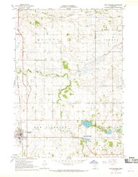
1967 Map of New Richland
USGS Topo · Published 1969About this map
New Richland serves as the primary hub of this south-central Minnesota landscape in the late 1960s, situated along the Chicago and North Western railroad line. The map reveals a highly structured agricultural environment defined by an extensive drainage network, including County Ditch No 33 and Ditch No 5, which feed into the meandering Le Sueur River. For genealogists, the survey identifies numerous small community burial sites such as Otisco Cem, Calvary Cem, and the Otisco-Lemond Cem further north. Cultural landmarks like the Le Sueur River Ch and School No 2137 illustrate the dispersed rural settlement pattern of Waseca and Steele Counties. Natural features like St Olaf Lake and the Teal State Wildlife Management Area provide contrast to the rectilinear grid of township boundaries and farmstead roads.
Find a feature on this map
29 named features on this map. Tap any name to fly to it.
Don’t see what you’re looking for? This feature index may not catch every label — zoom into the map to look around manually.
Map Details
Editions of this 1967 New Richland Map
This is the sole edition of this map. No revisions or reprints were ever made.
Other maps of this area

1953 · Saint Paul
USGS Topo · 1:250,000

1954 · Mason City
USGS Topo · 1:250,000

1957 · Mason City
USGS Topo · 1:250,000

1958 · Mason City
USGS Topo · 1:250,000

1959 · Saint Paul
USGS Topo · 1:250,000

1962 · Saco
USGS Topo · 1:24,000

1962 · Meriden
USGS Topo · 1:24,000

1966 · Waseca
USGS Topo · 1:24,000

1967 · Freeborn
USGS Topo · 1:24,000
1967 · Otisco
USGS Topo · 1:24,000