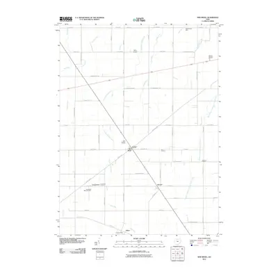
2010 Map of New Riegel
USGS Topo · Published 2010About this map
New Riegel stands as the primary hub of this agricultural landscape in Seneca County, characterized by a dense network of township and county roads that carve the terrain into neat geometric sections. The importance of local heritage is evident in the numerous burial grounds scattered across the area, including Saint Boniface Cemetery near the village center and the Seneca Memory Gardens to the northeast. These sites, along with Frenchtown Cemetery and Reisz Cemetery, provide valuable anchor points for genealogical research in this part of Ohio.
Find a feature on this map
57 named features on this map. Tap any name to fly to it.
Don’t see what you’re looking for? This feature index may not catch every label — zoom into the map to look around manually.
Map Details
Editions of this 2010 New Riegel Map
This is the sole edition of this map. No revisions or reprints were ever made.
Other maps of this area

1901 · Fostoria
USGS Topo · 1:62,500

1903 · Fostoria
USGS Topo · 1:62,500

1906 · Sycamore
USGS Topo · 1:62,500

1906 · Tiffin
USGS Topo · 1:62,500

1907 · Upper Sandusky
USGS Topo · 1:62,500

1950 · Marion
USGS Topo · 1:250,000

1956 · Toledo
USGS Topo · 1:250,000

1960 · Sycamore
USGS Topo · 1:24,000

1960 · Tiffin South
USGS Topo · 1:24,000
1960 · Bascom
USGS Topo · 1:24,000