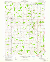
1960 Map of New Washington
USGS Topo · Published 1961About this map
Agricultural patterns and historical boundaries define this 1960s study of north-central Ohio, where the village of New Washington serves as the primary hub. The map captures a transition in transportation infrastructure, showing the Akron Canton and Youngstown railroad in operation through the north while the Pennsylvania Railroad Grade runs southeast through Tiro. This era reveals a landscape still deeply rooted in its early nineteenth-century surveying legacy, marked by the Congress Lands North of Old Seven Ranges and its intersection with the First Principal Meridian.
Find a feature on this map
49 named features on this map. Tap any name to fly to it.
Don’t see what you’re looking for? This feature index may not catch every label — zoom into the map to look around manually.
Map Details
Editions of this 1960 New Washington Map
2 editions found
Other maps of this area

1915 · Norwalk
USGS Topo · 1:62,500

1915 · Siam
USGS Topo · 1:62,500

1915 · Bucyrus
USGS Topo · 1:62,500

1915 · Crestline
USGS Topo · 1:62,500

1943 · Bucyrus
USGS Topo · 1:62,500

1943 · Crestline
USGS Topo · 1:62,500

1944 · Norwalk
USGS Topo · 1:62,500

1950 · Marion
USGS Topo · 1:250,000

1956 · Toledo
USGS Topo · 1:250,000

1960 · North Robinson
USGS Topo · 1:24,000