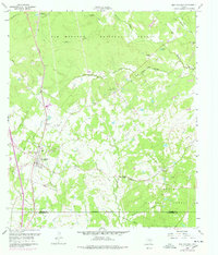
1960 Map of New Waverly
USGS Topo · Published 1978About this map
New Waverly sits at the heart of this survey, serving as a primary hub along the Missouri Pacific railroad. The landscape is a mosaic of timberland within the Sam Houston National Forest and rural settlements like Elmina, where the Elmina Sch and St Joseph Ch supported the local community. The mapping reflects a transition in transportation, showing both active rail lines and an Old Railroad Grade near Hawthorne, hinting at the area's evolving timber and transport economy.
Find a feature on this map
40 named features on this map. Tap any name to fly to it.
Don’t see what you’re looking for? This feature index may not catch every label — zoom into the map to look around manually.
Map Details
Editions of this 1960 New Waverly Map
3 editions found
Other maps of this area

1954 · Beaumont
USGS Topo · 1:250,000

1957 · Beaumont
USGS Topo · 1:250,000

1958 · Lake Paula
USGS Topo · 1:24,000

1959 · Moore Grove
USGS Topo · 1:24,000

1959 · Conroe NE
USGS Topo · 1:24,000

1960 · Willis
USGS Topo · 1:24,000

1960 · Maynard
USGS Topo · 1:24,000

1960 · New Waverly
USGS Topo · 1:24,000

1960 · Phelps
USGS Topo · 1:24,000

1961 · Oakhurst
USGS Topo · 1:24,000