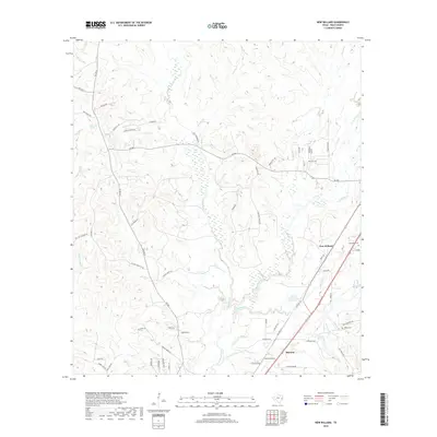
2019 Map of New Willard
USGS Topo · Published 2019About this map
Long King Creek and its many tributaries, including Alexander Creek and Sandy Creek, carve a detailed drainage network through this portion of Polk County. The settlement patterns are concentrated along the primary north-south transportation corridors, most notably at New Willard and Marston. These communities represent the long-standing timber and agricultural hubs of East Texas, where the local economy has historically been tied to the surrounding woodlands. Genealogists will find significant value in the documentation of local burial sites, such as Alexander Cemetery and Kibble Cemetery, situated near the residential clusters. The map also identifies specific natural water sources like Bold Springs and Kokernot Spring, which served as vital landmarks for early settlers in the region. The road network, including FM 350 N and FM 942, connects these dispersed settlements and named family tracts like Fagan Farm Road.
Find a feature on this map
65 named features on this map. Tap any name to fly to it.
Don’t see what you’re looking for? This feature index may not catch every label — zoom into the map to look around manually.
Map Details
Editions of this 2019 New Willard Map
This is the sole edition of this map. No revisions or reprints were ever made.
Other maps of this area

1954 · Beaumont
USGS Topo · 1:250,000

1955 · New Willard
USGS Topo · 1:62,500

1957 · Beaumont
USGS Topo · 1:250,000

1958 · Livingston
USGS Topo · 1:62,500

1960 · Blanchard
USGS Topo · 1:24,000

1960 · Colita
USGS Topo · 1:24,000

1961 · Onalaska
USGS Topo · 1:24,000

1984 · Soda
USGS Topo · 1:24,000

1984 · Beaumont
USGS Topo · 1:250,000
1984 · Livingston
USGS Topo · 1:24,000