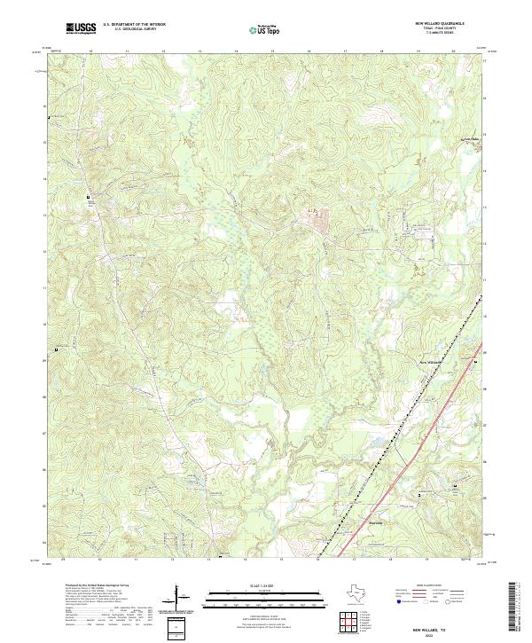
2022 Map of New Willard
USGS Topo · Published 2022About this map
Bold Springs and New Willard anchor a landscape defined by the winding tributaries of the Neches River basin. The area is characterized by a dense network of local roads and cemeteries, reflecting a long-standing rural community structure. To the north, Seven Oaks sits near the headwaters of Long King Creek, while the southern reaches near Marston are intersected by Alexander Creek and Kibbie Creek. Genealogists will find a significant concentration of burial sites, including Fairfield Cem, Peg Top Cem, and Oakdale Cem, often located near established homesteads or springs such as Kokernot Spring. The map documents a complex drainage system where Long Tom Creek and Sandy Creek meander through the central timberlands, illustrating the natural watercourses that have shaped Polk County's settlement patterns and local transit routes like FM 350 N and FM 942.
Find a feature on this map
74 named features on this map. Tap any name to fly to it.
Don’t see what you’re looking for? This feature index may not catch every label — zoom into the map to look around manually.
Map Details
Editions of this 2022 New Willard Map
This is the sole edition of this map. No revisions or reprints were ever made.
Other maps of this area

1954 · Beaumont
USGS Topo · 1:250,000

1955 · New Willard
USGS Topo · 1:62,500

1957 · Beaumont
USGS Topo · 1:250,000

1958 · Livingston
USGS Topo · 1:62,500

1960 · Blanchard
USGS Topo · 1:24,000

1960 · Colita
USGS Topo · 1:24,000

1961 · Onalaska
USGS Topo · 1:24,000

1984 · Soda
USGS Topo · 1:24,000

1984 · Beaumont
USGS Topo · 1:250,000
1984 · Livingston
USGS Topo · 1:24,000