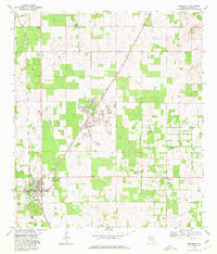
1968 Map of Newberry
USGS Topo · Published 1980About this map
Industrial and rural landscapes intersect in this Alachua County study, where the Seaboard Coast Line railroad cuts a diagonal path through the terrain. The town of Newberry serves as a primary hub, featuring a High Sch and a Landing Field, while the smaller settlement of Haile is defined by its extensive mining operations. Numerous Quarry sites and a Tipple underscore the region's reliance on mineral extraction during this era. Scattered communities like Jonesville, Wade, and Forest Grove provide a glimpse into the local social fabric, centered around institutions like Jonesville Ch and Oak Dale Ch. The topography is marked by a distinctive sinkhole-rich landscape, where the interplay of limestone mining and traditional agriculture shaped the development of northern Florida in the late 1960s.
Find a feature on this map
19 named features on this map. Tap any name to fly to it.
Don’t see what you’re looking for? This feature index may not catch every label — zoom into the map to look around manually.
Map Details
Editions of this 1968 Newberry Map
4 editions found

Other maps of this area

1890 · Arredondo
USGS Topo · 1:62,500

1892 · Arredondo
USGS Topo · 1:62,500

1894 · Arredondo
USGS Topo · 1:62,500

1954 · Gainesville
USGS Topo · 1:250,000

1958 · Gainesville
USGS Topo · 1:250,000

1959 · Gainesville
USGS Topo · 1:250,000

1962 · High Springs
USGS Topo · 1:24,000

1966 · Gainesville West
USGS Topo · 1:24,000

1966 · Arredondo
USGS Topo · 1:24,000
1966 · Alachua
USGS Topo · 1:24,000