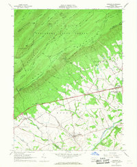
1966 Map of Newburg
USGS Topo · Published 1968About this map
Newburg sits at the heart of this landscape, a concentration of valley life where rural lanes converge near Conodoguinet Creek. The southern half of the map is defined by the agricultural rhythms of Hopewell and Lurgan townships, while the northern half rises sharply into the protected wilderness of the Tuscarora State Forest. This mid-century view shows a rural economy in transition, where the modern Pennsylvania Turnpike and Interchange 15 cut a high-speed path across the traditional farmsteads and creek valleys.
Find a feature on this map
53 named features on this map. Tap any name to fly to it.
Don’t see what you’re looking for? This feature index may not catch every label — zoom into the map to look around manually.
Map Details
Editions of this 1966 Newburg Map
2 editions found
Other maps of this area

1919 · Newville
USGS Topo · 1:62,500

1919 · Mattawana
USGS Topo · 1:62,500

1923 · Shippensburg
USGS Topo · 1:62,500

1930 · Loysville
USGS Topo · 1:62,500

1933 · Loysville
USGS Topo · 1:62,500

1936 · East Waterford
USGS Topo · 1:48,000

1941 · East Waterford
USGS Topo · 1:62,500

1943 · Shippensburg
USGS Topo · 1:62,500

1945 · Newville
USGS Topo · 1:62,500

1945 · Shippensburg
USGS Topo · 1:62,500
Featured Places
- Lurgan Township, PA
- Newburg, Hopewell Township
- North Newton Township, PA
- Lower Mifflin Township, PA
- Jackson Township, PA