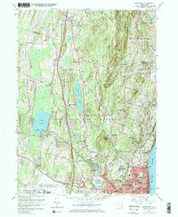
1957 Map of Newburgh
USGS Topo · Published 1968About this map
The Hudson River waterfront and the expanding city of Newburgh anchor this mid-century survey of Orange County. The landscape is a transition between the dense urban grid of the river port and the rising elevations of Marlborough Mountain and Cronomer Hill. Inland, the area is defined by significant water bodies such as Chadwick Lake and Orange Lake, the latter featuring the Pine Pt Casino. The arrival of the New York State Thruway is clearly visible, cutting north-south through a region still heavily dotted with community landmarks like Our Lady of Fatima Ch and Savilton.
Find a feature on this map
58 named features on this map. Tap any name to fly to it.
Don’t see what you’re looking for? This feature index may not catch every label — zoom into the map to look around manually.
Map Details
Editions of this 1957 Newburgh Map
4 editions found
Other maps of this area

1892 · West Point
USGS Topo · 1:62,500

1893 · Poughkeepsie
USGS Topo · 1:62,500

1894 · West Point
USGS Topo · 1:62,500

1894 · Poughkeepsie
USGS Topo · 1:62,500

1899 · West Point
USGS Topo · 1:62,500

1901 · West Point
USGS Topo · 1:62,500

1902 · Schunemunk
USGS Topo · 1:62,500

1903 · Poughkeepsie
USGS Topo · 1:62,500

1903 · Newburg
USGS Topo · 1:62,500

1930 · Schunemunk
USGS Topo · 1:48,000