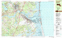
1987 Map of Newburyport
USGS Topo · Published 1987About this map
The Merrimack River dominates this coastal landscape as it flows past Amesbury, Salisbury Point, and the historic port city of Newburyport. By the late 1980s, the area reflects a complex balance between established urban centers and extensive conservation lands. The city's maritime heritage is anchored by the Newburyport Light and the USCG Station, while the vast Parker River National Wildlife Refuge and Joppa Flats preserve the sensitive tidal environment of Plum Island.
Find a feature on this map
117 named features on this map. Tap any name to fly to it.
Don’t see what you’re looking for? This feature index may not catch every label — zoom into the map to look around manually.
Map Details
Editions of this 1987 Newburyport Map
2 editions found
Other maps of this area

1886 · Gloucester
USGS Topo · 1:62,500

1886 · Lawrence
USGS Topo · 1:62,500

1888 · Newburyport
USGS Topo · 1:62,500

1888 · Haverhill
USGS Topo · 1:62,500

1888 · Gloucester
USGS Topo · 1:62,500

1888 · Lawrence
USGS Topo · 1:62,500

1888 · Salem
USGS Topo · 1:62,500

1890 · Haverhill
USGS Topo · 1:62,500

1890 · Newburyport
USGS Topo · 1:62,500

1893 · Salem
USGS Topo · 1:62,500