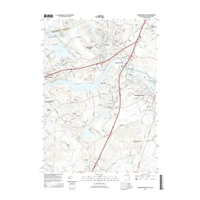
2015 Map of Newburyport West
USGS Topo · Published 2015About this map
The Merrimack River serves as the central artery for this region of the North Shore, where the industrial history of Amesbury Town and Newburyport meets the rural character of the Merrimack Valley. The landscape is defined by a dense network of glacial hills, including Powder House Hill and Whittier Hill, which overlook the complex waterways of Lake Gardner and the Powwow River. Historical land use is evident in the numerous burial grounds and cemeteries that dot the map, such as the Sawyer Hill Burying Ground and Highland Cemetery. Transportation corridors bridge the past and present, with the Whittier Memorial Bridge spanning the river near Deer Island while smaller settlements like Merrimacport and Byfield maintain their distinct geographic identities. Further south, the Parker River and Crane Pond reflect the more open, wetland-rich terrain typical of the area's inland reaches.
Find a feature on this map
73 named features on this map. Tap any name to fly to it.
Don’t see what you’re looking for? This feature index may not catch every label — zoom into the map to look around manually.
Map Details
Editions of this 2015 Newburyport West Map
This is the sole edition of this map. No revisions or reprints were ever made.
Other maps of this area

1886 · Lawrence
USGS Topo · 1:62,500

1888 · Newburyport
USGS Topo · 1:62,500

1888 · Haverhill
USGS Topo · 1:62,500

1888 · Lawrence
USGS Topo · 1:62,500

1888 · Salem
USGS Topo · 1:62,500

1890 · Haverhill
USGS Topo · 1:62,500

1890 · Newburyport
USGS Topo · 1:62,500

1893 · Salem
USGS Topo · 1:62,500

1893 · Lawrence
USGS Topo · 1:62,500

1893 · Haverhill
USGS Topo · 1:62,500