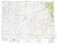
1955 Map of Newcastle
USGS Topo · Published 1976About this map
Newcastle serves as the primary hub in this mid-century portrait of eastern Wyoming and the South Dakota borderlands, situated where the Burlington Northern railroad meets the southwestern edge of the Black Hills National Forest. The landscape is defined by its drainage basins, dominated by the Cheyenne River and its numerous tributaries like Little Thunder Creek and Black Thunder Creek, which carve through the high plains. This 1955 survey captures the region's energy economy through numerous oil fields and a Pumping Station near the border, alongside traditional ranching settlements like Osage, Clareton, and Lance Creek. Historical transit is preserved with the Bozeman Trail Monument located in the western reaches, while the topographic relief is marked by prominent landforms including Mount Pisgah and a series of distinct peaks such as North Butte and South Butte.
Find a feature on this map
71 named features on this map. Tap any name to fly to it.
Don’t see what you’re looking for? This feature index may not catch every label — zoom into the map to look around manually.
Map Details
Editions of this 1955 Newcastle Map
2 editions found

Other maps of this area

1894 · Deadwood
USGS Topo · 1:125,000

1896 · Harney Peak
USGS Topo · 1:125,000

1898 · Sundance
USGS Topo · 1:125,000

1899 · Newcastle
USGS Topo · 1:125,000

1901 · Harney Peak
USGS Topo · 1:125,000

1901 · Deadwood
USGS Topo · 1:125,000

1901 · Newcastle
USGS Topo · 1:125,000

1902 · Sundance
USGS Topo · 1:125,000

1902 · Edgemont
USGS Topo · 1:125,000

1916 · Deadwood
USGS Topo · 1:125,000