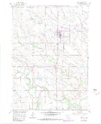
1951 Map of Newell
USGS Topo · Published 1980About this map
The Belle Fourche River valley serves as the agricultural and industrial backbone of this northern plains landscape during the early 1950s. Centered on the town of Newell, the map documents a sophisticated irrigation network vital to the region's ranching and farming operations, including the Calhoun Ditch and numerous named laterals like the Mc Lung Lateral and Baldwin Lateral. This system, managed in part through the Newell Experiment Station, transformed the semi-arid terrain of Butte County into a productive corridor.
Find a feature on this map
36 named features on this map. Tap any name to fly to it.
Don’t see what you’re looking for? This feature index may not catch every label — zoom into the map to look around manually.
Map Details
Editions of this 1951 Newell Map
2 editions found
Other maps of this area

1905 · Saint Onge
USGS Topo · 1:62,500

1906 · Two Top
USGS Topo · 1:62,500

1906 · Vale
USGS Topo · 1:62,500

1907 · Belle Fourche
USGS Topo · 1:125,000

1913 · Newell
USGS Topo · 1:125,000

1951 · Vale
USGS Topo · 1:24,000

1951 · Vale SE
USGS Topo · 1:24,000

1951 · Newell
USGS Topo · 1:24,000

1951 · Vale NE
USGS Topo · 1:24,000
1951 · Nisland
USGS Topo · 1:24,000