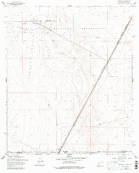
1955 Map of Newman
USGS Topo · Published 1979About this map
Fort Bliss Military Reservation dominates this mid-century desert landscape at the border of New Mexico and Texas. The terrain of the Tularosa Valley is defined by a sparse network of military and transportation infrastructure, including a Landing Strip In Road and a Meteorological Station near the northern boundary. The Southern Pacific railroad cuts a straight diagonal across the basin, serving as a primary transit corridor through this arid environment. Near the southern edge of the sheet, the small settlement of Newman sits at the junction of the state line and the railroad, providing a rare point of habitation. The presence of Ruins and scattered Well sites highlights the challenges of settlement and the military's use of this expansive desert reach for training and observation during the mid-1950s.
Find a feature on this map
15 named features on this map. Tap any name to fly to it.
Don’t see what you’re looking for? This feature index may not catch every label — zoom into the map to look around manually.
Map Details
Editions of this 1955 Newman Map
2 editions found
Other maps of this area

1896 · El Paso
USGS Topo · 1:125,000

1908 · El Paso
USGS Topo · 1:125,000

1939 · Heuco Tanks
USGS Topo · 1:62,500

1940 · Heuco Tanks
USGS Topo · 1:62,500

1940 · Newman
USGS Topo · 1:62,500

1941 · Desert
USGS Topo · 1:62,500

1942 · Fort Bliss
USGS Topo · 1:62,500

1943 · Desert
USGS Topo · 1:62,500

1943 · Newman
USGS Topo · 1:62,500

1944 · Heuco Tanks
USGS Topo · 1:62,500